Saturday, November 5, 2011

Mary - 09-29-11 WY/UT Trip - Zion National Park

Zion National Park is known for its incredible canyons, including The Narrows, which attract canyoneers from around the world.Only shuttle buses are allowed to travel the scenic roads in the park so some of the pictures are from a moving vehicle and not as clear and, as with all the pictures, the sun wasn't always in the right spot for the best shots. The park has four main sections. We visited the most popular section, Zion Canyon. The Virgin River has gnawed through native sandstone to create the incredible scenery found in Zion Canyon.

The shot with the river is the first taken from a short trail we hiked near the visitor center. See if you can spot the 'snake' in the tree branches. The squirrel was great fun to watch. He/she was apparently building a nest. We watched him run across the path three or four times. He would drop down the side on the right and come back with a mouth full of leaves, run across the trail and up the boulders on the left, disappear in the rocks and then come back out and check to see if he was being watched -- which didn't stop him from his mission. Too cute. The last shot at the campground is of a camping macaw and an African Grey parrot -- note, neither are inside their cages.


Very long, low tunnel ...
RVs had to be escorted through ....
we didn't take the RV on this road.


Virgin River

The 'snake'


Squirrel returning to trail with leaves

Squirrel deposited leaves higher up and is about
to scamper back across the trail for more ...


Macaw with back to the camera but
turning his head for a nice profile shot.
African grey sitting on open door of cage is
more interested in cleaning than posing for the camera.

Sunday, October 23, 2011

Figment – 09-28-11 WY/UT Trip – Panguitch, UT to Hurricane, UT

Took the long road today! Mama Conni took me on a long route today to prevent going over 7%+ grades. Of course I think I could have made it J  One real surprise was seeing 80 mph speed limits. That’s a first. It was in several sections of Interstate 15 and was stated as a “test”. I didn’t get to do that though. I had to plug along at 60 or 65 to conserve my appetite and to be safe. Hmmm, they both get a little testy when I eat too much.
It started out going thru some more beautiful canyons, then stretches of desert. We took a windy road off the Interstate to Hurricane, UT. They pronounce it Hurri-cunh – really fast, not like my fellow Americans, but like the British.
Finally!!!!! I got a bath! The mamas sprung for a professional hand wash for me. I feel so good now. Even my top was scrubbed. My feet are all shiny too. I’m sure I’m the envy of the whole park. BTW, the park is the best I’ve ever stayed in. All concrete paved streets and pads, trees, and a little grass for each of us. I could live here J

Mary - 9-25/27-11 WY/UT Trip - Bryce Canyon National Park

Our trip has taken us to Yellowstone and the Grand Tetons in Wyoming and to Dead Horse Point, Canyonlands and Arches in Utah. As I looked over the route to Bryce last night and discovered it was in a remote area and required backtracking for many, many miles, I wondered if it could be so different or more impressive than all the other incredible places we've seen. Conni reminded me my original dream of the trip was to see all the parks in southern Utah so we were off to Bryce Canyon. It was a very good decision.

Bryce, named after Ebenezer Bryce, who originally inhabited the area, is located in southwest Utah. Bryce, which is not actually a canyon, consists of rock structures called hoodoos. Hoodoos were created by years and years of erosion. The 18 miles of park road follows the plateau rim. The road and overlooks provide stunning panoramic views.

Enjoy the pictures. Tomorrow, we are off to Zion.

Bryce National Park - Overlook at Visitor Center


Waiting for the bus ...

Best pie ever .... glad we made this u-turn!

Thursday, October 20, 2011

Mary - 9-24-11 WY/UT Trip - Arches National Park, UT

Water and ice, extreme temperatures, and underground salt movement are responsible for the sculptured rock scenery of Arches National Park. There are over 2,000 arches ranging in size from three foot openings to 306 feet base to base. We didn't see many of the best known arches due to miles long trails; however, those we did see were amazing. I've include a lot of photos since all the rock formations were so incredible. Unfortunately, I don't recall all the rock's names. We will be leaving the Moab area and heading to Bryce tomorrow.
Entrance to Arches National Park


Seems like this would just slide off ...
Slab like rocks called fins.


The Organ

The Gossips


Balance Rock
 
Delicate Arch


Unusual Plant

We were not at risk!

Rising up from desert.
Fins

Sadie baby a week after surgery. Half of left eye sewn shut.
It is really that red - not 'camera flash' red eye.
Note her e-collar (Elizabethan Collar).

Saturday, October 15, 2011

Mary - 9-23-11 WY/UT Trip - Canyonlands National Park, UT

Canyonlands, located near Moab in southeast Utah, is Utah’s largest national park. You can look thousands of feet down to the whitewater rapids of the Colorado River or thousands of feet up to the soaring red rock pinnacles, cliffs and spires. The park is divided into three districts. We visited the Island in the Sky district. This is a wide, high plateau with commanding views across many miles of deep red rock canyons in all directions. We did a little hiking - and survived.

Tomorrow, a drive through Arches National Park.


Cliff overlooking Shafer Canyon

Symbols of a protective entity along the trail to the cliff
(as seen by a number of native cultures)
Our symbol

View of Shafer Canyon from Overlook
Note the Road ....


View of Shafer Canyon


Conni and "Toad" (tow Jeep)


Canyons Carved by Rivers

Us

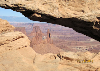
Arch in Canyonlands


View through the Arch


Trees are hundreds of years old but lack of rain prevents growing tall

Sunset View of La Sal Mountains from RV Park

Canyons and more Canyons